Things to do in Point Loma: Lighthouse, Cliffs and Bay Views
A plain guide to Point Loma's national monument, old lighthouse, ocean cliffs, bayside walks and former naval training grounds.
8 Oct 2026
Point Loma is a hilly peninsula in San Diego. The Pacific Ocean lies on its west and south sides, and San Diego Bay lies on the east. The San Diego River marks the northern edge. It covers roughly 4,400 acres, and nearly all of it is a short ride from downtown.
This is where California's European story begins. In 1542 the explorer Juan Rodriguez Cabrillo sailed in and called the bay "a very good enclosed port." Most of what draws people here has been in place for decades and is likely to stay.
Cabrillo National Monument
Cabrillo National Monument sits at the southern tip of the peninsula. It is run by the National Park Service and remembers Cabrillo's 1542 arrival, which makes him the first European to set foot on what is now the West Coast of the United States.
The visitor center is the starting point. It has displays on exploration and on the Native peoples who lived here first. Outside, you look across San Diego and Coronado, with the bay on one side and the ocean on the other.
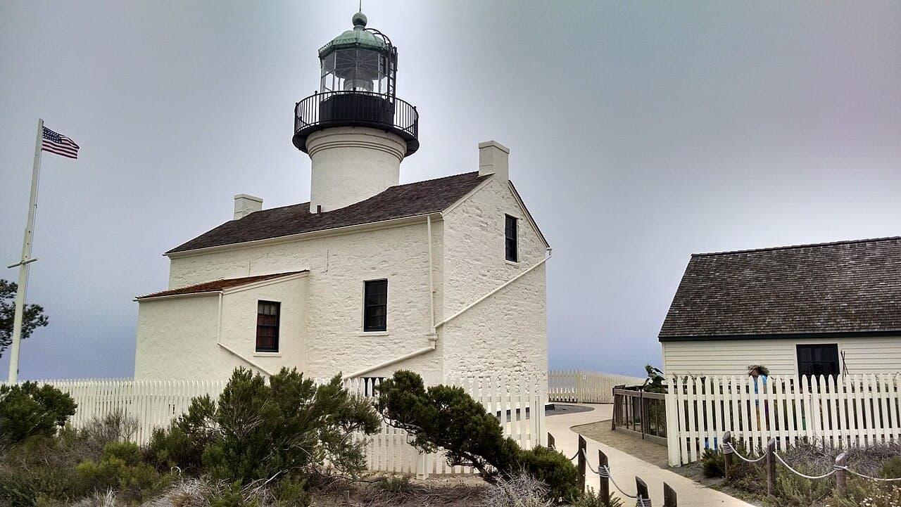
The Old Point Loma Lighthouse is the star of the park. It was finished in 1854 and first lit in November 1855. It stands 422 feet above the sea, and that was the problem. Fog often hid the beam, so a newer lighthouse was built much closer to the water in 1891. The old one is now a quiet piece of maritime history, surrounded by spring wildflowers.
Three trails start from the monument. The Coastal Trail is open daily. The Oceanside Trail links the upper park to the tide pools. The Bayside Trail begins near the old lighthouse. At low tide the tide pools show off sea creatures that hide at other times. There is also a whale overlook for watching for whales.
Cliffs and coast
Sunset Cliffs runs along the ocean side of the peninsula. Its sandstone cliffs make a favorite place to watch the sun go down over the Pacific. The cliffs are not stable, so keep well back from the edge and follow any posted signs. A secluded surfing beach below is meant only for expert surfers, and there are no lifeguards there.
Bayside walks
Shelter Island is not really an island. It is a man-made strip of land that was once a sandbank in San Diego Bay. Dredged material built it up in the 1930s and again during World War II. Today it is about 1.2 miles long and only a few hundred feet wide. Shelter Island Shoreline Park runs along the water and is cared for by the Port of San Diego.
Walk the shoreline to find the Yokohama Friendship Bell, a bronze bell in a small pagoda. Yokohama, Japan gave it in 1958 to honor its sister city ties with San Diego. A bronze sculpture nearby honors the tuna fishermen who built the area's early economy. The Pearl of the Pacific is a round fountain with mosaic walls, popular for outdoor weddings.
Liberty Station is a 361 acre former Naval Training Center. The Navy closed the base in 1997, and the site is now on the National Register of Historic Places. More than 50 of its buildings have been renovated. It has an arts district with galleries and theaters in historic buildings, a 46 acre waterfront park, and a two thirds size model of a Navy training ship, USS Recruit, that you can tour. The 52 Boats Memorial there honors submarines and submariners lost in World War II.
Places of quiet
Fort Rosecrans National Cemetery sits on the hill above the bay and the ocean. It began in 1882 and became a national cemetery in 1934. It spans about 77 acres and is a place for quiet reflection, with views of both the bay and the Pacific. Visit with respect.
For families
The monument's tide pools and whale overlook are the highlights for children. Liberty Station's waterfront park gives them open lawn to run on, and the USS Recruit model is a fun way to learn about Navy life.
When the weather turns
On a foggy or wet day, the Cabrillo visitor center and the Liberty Station galleries are good indoor stops. The lighthouse views are best when it is clear, so check the monument's website for current conditions.
A short drive away
Old Town San Diego State Historic Park is a few miles up the road. It preserves the early story of San Diego with restored buildings, five original adobes and a working blacksmith shop. Ocean Beach lies at the north end of the peninsula, with a long sandy beach and Dog Beach, where dogs may run free.
Getting around
Rosecrans Street, Harbor Drive and Nimitz Boulevard lead onto the peninsula. A few bus routes serve the area, though service is limited, and the route to the monument runs on weekdays only. Many visitors drive. San Diego International Airport is less than ten minutes away.
Good to know
Stay back from the edge at Sunset Cliffs. The sandstone is crumbling.
Tide pools are best at low tide. Check the tide before you go.
Bring layers. The ocean is cool most of the year.
The monument has an entrance fee, so check the NPS website before you go.
Visit the cemetery quietly and respectfully.
Find local businesses
Planning a visit, or live nearby and need a hand with something? Browse the local businesses listed in the San Diego guide to find who serves Point Loma and the neighborhoods around it.
Useful links
About Point Loma: the town at a glance
Own a business in Point Loma? Claim or add your listing, free
By Thomas Hassett and Eric Andrews, Local Business America
Photo: Stovk64, CC BY-SA 4.0, via Wikimedia Commons.
Sources: Wikipedia, "Point Loma, San Diego" (https://en.wikipedia.org/wiki/Point_Loma,_San_Diego); Wikivoyage, "San Diego/Point Loma-Ocean Beach" (https://en.wikivoyage.org/wiki/San_Diego/Point_Loma); National Park Service, "Cabrillo National Monument" (https://www.nps.gov/cabr/index.htm); Wikipedia, "Liberty Station" (https://en.wikipedia.org/wiki/Liberty_Station); Wikipedia, "Shelter Island, San Diego" (https://en.wikipedia.org/wiki/Shelter_Island,_San_Diego); Wikipedia, "Fort Rosecrans National Cemetery" (https://en.wikipedia.org/wiki/Fort_Rosecrans_National_Cemetery); California State Parks, "Old Town San Diego State Historic Park" (https://www.parks.ca.gov/?page_id=663). Wikipedia and Wikivoyage text is available under CC BY-SA.